")
")

THE PROJECT
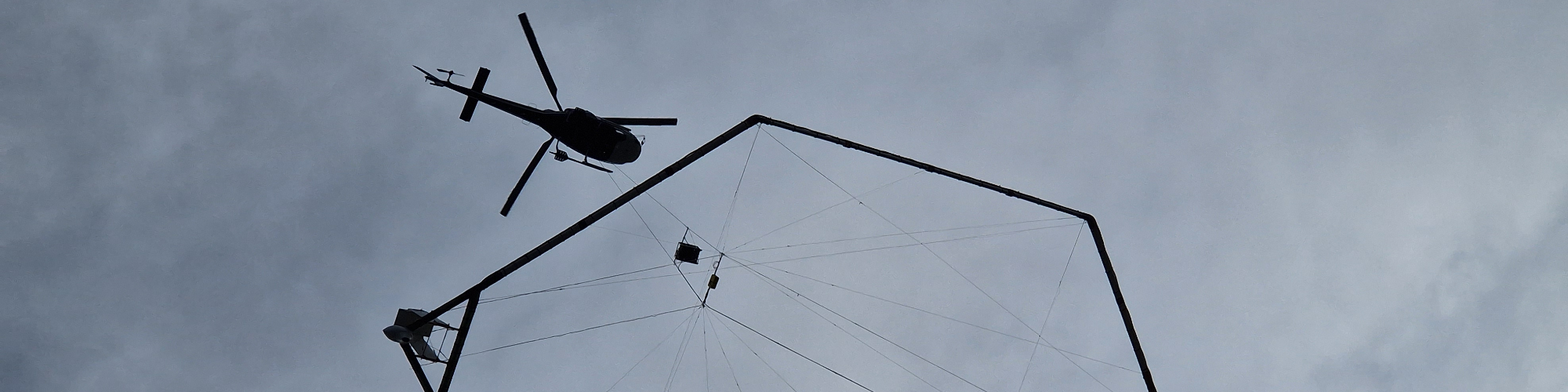
What is happening in the skies over Barbagia? INGV, in collaboration with the University of Cagliari, has commissioned a geophysical survey to map the geological and hydrogeological structure of the subsurface in the area being considered as the site for the Einstein Telescope. The survey is carried out using the AEM (Airborne ElectroMagnetics) technique, with a helicopter towing a large hexagonal antenna (40 metres in diameter).
What is the Einstein Telescope? A next-generation underground gravitational wave detector. Sardinia is Italy's candidate to host the infrastructure in the area surrounding the Sos Enattos mine, in the Nuoro province.
Who manages the project? INGV (the National Institute of Geophysics and Volcanology), in collaboration with the University of Cagliari, as part of the European Einstein Telescope project and the ET Italia collaboration. The survey is carried out by SkyTem, a Danish company and world leader in AEM technology. There are currently no Sardinian companies specialising in this technology.
Has this survey method been used before? Yes. The AEM method is used regularly around the world. In Italy, it has already been applied in the Sulcis region, the Venetian Lagoon, the province of Brescia, and Sicily.
What is the expected outcome? The creation of a 3D map of the geological and hydrogeological structure of the subsurface down to a depth of 500 metres. The data collected will be made available to local authorities to support more accurate land-use planning, and will be published in scientific literature.
THE SURVEY FLIGHTS
Which areas are involved? The survey will cover an area of approximately 400 square kilometres, mainly across the municipalities of Lula, Bitti, Orune, and Onanì, and to a lesser extent the municipalities of Benetutti, Nule, Buddusò, Alà dei Sardi, and Lodè, as shown on the map.
At what altitude does the helicopter fly? The helicopter flies at approximately 50 metres above the ground. The hexagonal antenna is suspended at approximately 30 metres above the ground. The base of operations is located near the sports ground in Lula.
What is the structure hanging beneath the helicopter? A hexagonal antenna, 40 metres in diameter, that generates a primary magnetic field directed towards the ground. By measuring the secondary magnetic field produced by the subsurface, it provides information on the geological and hydrogeological composition down to a depth of 500 metres.
How long will the survey take? Three flights of approximately 2 hours each are planned per day. The time spent flying over any specific area is just a few tens of seconds. The overall survey is estimated to last 3 to 4 weeks, depending on weather conditions. The data collected will then require several months of processing to build the 3D geological model.
Are there any time restrictions on flights? Flights are conducted in the morning and afternoon only. No night flights are planned, and operations will not take place in bad weather or strong winds.
Will the helicopter fly over residential areas? No. Flights are restricted to rural areas. The helicopter will not fly over buildings, urban areas, or infrastructure.
When will the helicopter fly over my area? Flight plans will be communicated two days in advance through the official channels of INGV (this link) and the relevant municipal authorities, so that residents can take the necessary precautionary measures.
SAFETY AND HEALTH
Is the survey harmful to human health? No. The electromagnetic emissions from the antenna are lower in intensity than the Earth's natural magnetic field, to which we are exposed every day. There is no risk for people working in the fields during the helicopter's passage either.
Could it disturb livestock or domestic animals? The electromagnetic emissions are completely harmless to animals. However, the noise from the rotor — comparable to that of a chainsaw (90–110 decibels) for anyone directly beneath the helicopter — may startle horses and other animals. The overflight is brief. Precautionary measures are recommended, especially for horses.
Could the system damage crops or land? No. There will be no alteration of the soil or crops, no harmful emissions, and no impact on wildlife.
Could the antenna detach and fall? This is extremely unlikely. The helicopter only flies in optimal weather conditions, and the pilots are experienced and trained to handle any unforeseen circumstances.
PRIVACY
Will any video or photographic recording take place? No. The helicopter is not equipped with cameras. The privacy of residents will not be compromised in any way. The antenna is designed to study the subsurface, not the surface.
CONTACTS AND FURTHER INFORMATION
Where can I find more information? Please visit: https://ccget.ingv.it
Who can I contact with questions or concerns? For any questions or reports, please contact INGV:
- Dr Carlo Giunchi, coordinator of the Geophysical Characterisation Centre for the Einstein Telescope:
This email address is being protected from spambots. You need JavaScript enabled to view it. - Dr Vincenzo Sapia, scientific coordinator of the survey:
This email address is being protected from spambots. You need JavaScript enabled to view it.